
Series Overview
A key mandate of the ALTER project was the design and deploy a WebGIS system for use by decision makers in planning for risks posed by dam failures. Near or complete failures of hydroelectric dams and tailing storage facilities (TSFs) in recent years have underscored the need for planning for these fast-moving and often catastrophic disasters. In Summer 2019, ALTER partners from the AUA Center for Responsible Mining and their partners at the Bulgarian Academy of Sciences completed both comprehensive failure models for dams and TSFs in southern Armenia and the underlying web-GIS system to display the models for non-technical users. The models were also presented to decision-makers and will be used in upcoming field exercises in Fall 2019.
This is the first in a series of articles that focuses on the development of both the webGIS system and the complex hydrological models. The system empowers decision makers to better understand risks to their communities and create plans to mitigate and ultimately minimize risk.
Study Areas
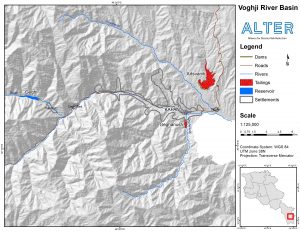
The first model developed was for the Geghi reservoir, a left bank tributary of the Voghji river which flows through the city of Kapan in southern Armenia. Also analyzed was the Geghanoush TSF, situated on the Geghanoush River just south of the city of Kapan. Neither dam had been comprehensively studied prior to the research done by the AUA Center for Responsible Mining.
Creating High Quality Data
Complex hydrological models that can accurately predict flooding in the wake of dam failures begins with high quality data from a number of sources. That data was then cleaned and analyzed before being fed into the models used to create flood predictions.
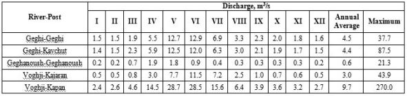
The first piece of data was hydro-meteorological observation data. Armenia’s Ministry of Emergency Situations (MES) keeps detailed records of flow rate and depth of rivers in the study area. The records date to 1930s and provided valuable information about both seasonal river height, but also data on historical small scale events that occured in the region. These records were requested by the team and were provided by the Ministry through ALTER partner ARNAP. While this data was comprehensive, the data required significant cleaning and formatting before it could be used in the system. This included importing and summarizing over 70 years worth of data.
MES and local municipalities also provided the team with shapefiles showing critical infrastructure and buildings. This data enables the final model to be applied to the real world and to show the real people in harm’s way were a dam failure to occur. The location of settlements and buildings is also critical for the timing of any failure. Understanding what people and infrastructure might be in danger is important, but more important may be the amount of time for evacuation and rescue between a dam failure and the arrival of a flood wave.
Elevation and terrain information used to predict flood crest heights was also important to model development. Georisk CJSC, that implemented the assessment of the multi-component risk assessment of Kapan City, provided the team with a five meter resolution (five
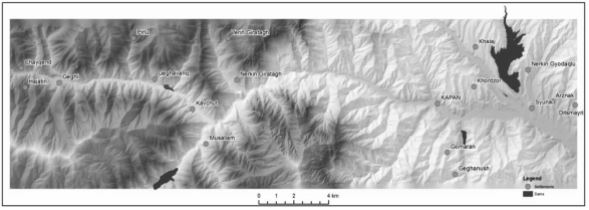
meters per pixel) digital elevation model created for the Kapan area. On top of the elevation model is the surface type model developed through land use/land cover analysis. Floods move differently across different surface types such as forest, agricultural land, or bare soil, thus any model must account for this.
Once all of the data was sufficiently cleaned and processed, it could then be fed into the dam failure model. The next article in this series will describe the model and the results derived for the failure of both the Geghi reservoir and the Geghanoush TSF.